ShopDreamUp AI ArtDreamUp

Deviation Actions


Suggested Deviants


Suggested Collections


Description
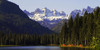
The view is from Owens Valley near the town of Lone Pine. The high peak at the center is Mount Whitney, at 14,505 feet (4,421 m) it is the highest point in the US outside Alaska. The Alabama Hills in the mid-ground are largely made up of granitic rock similar to that in the Sierra Nevada Batholith. Owens Valley is a down dropped, fault-bounded crustal block called a graben. Prior to about 2.5 million years ago, the Sierra Nevada and the Inyo Mountains to the east were one continuous landform, and Owens Valley did not exist. The steep eastern front of the Sierra Nevada is an eroded fault scarp. The epicenter of the Mw 7.9 March 26, 1872, Owens Valley earthquake is located on a fault line that parallels the east side of the Alabama Hills.
Image size
1600x1067px 388.91 KB
Make
Canon
Model
Canon EOS 6D
Shutter Speed
1/664 second
Aperture
F/16.0
Focal Length
85 mm
ISO Speed
320
Date Taken
Mar 4, 2016, 9:25:47 AM
© 2018 - 2024 RichardEly
Comments27
Join the community to add your comment. Already a deviant? Log In
I love seeing the different types of rocks on here; the 'rolling hill' in the foreground and the jagged mountains in the background  (Smile)")
I guess the 'L16P' on the hill there is Lone Pine 2016 [when it was done]?
This is actually a great testimony of Noah's Flood here [from a Christian/Creation POV that is] - and the effects the water had on the different types of rock (as well as the Ice Age that came after it)